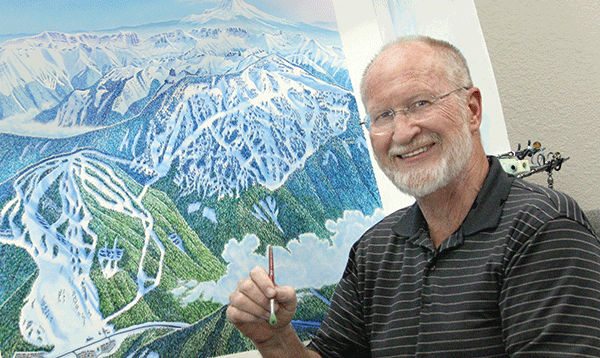
Meet James Niehues, the artist behind the trail map of Sugarbush – and just about all the other big mountain resorts in the U.S.
When you study Sugarbush’s trail map to figure out a good route from Middle Earth to Stein’s Run, do you ever wonder how that image of the mountain came to be? James Niehues, the premier ski-mountain artist in the world, spent weeks painstakingly drawing and painting Sugarbush’s trail map, just as he’s done for more than 160 other ski resorts in the United States, Austria, New Zealand, and elsewhere. He estimates that he’s depicted 75 percent of all large U.S. resorts.
In an era when more and more images are created on computers, Niehues argues—and his paintings back him up—that the task of capturing a complicated ski mountain is still best accomplished by the human mind and hand. He starts by taking aerial photographs of the mountain from 4,000 feet above the summit, then 2,000 feet, then lower, dropping with each pass until he reaches just a few hundred feet above the base. By the time he lands, he usually has an idea of the angle he’ll take for the mountain, and how he’ll twist the multiple faces to capture the best views of all the runs. “There’s usually just that one key perspective that will work best—I don’t know how to tell you that I get it. It’s manipulating the ski area in your mind and considering all the things that come into play. Each mountain has its own formula.”
In his studio in Loveland, Colorado, Niehues does a sketch of the mountain and sends it to the client for approval. Then he begins the longer, more detailed painting process, which usually takes a couple of weeks. He airbrushes the sky and the snow, but then uses gouache, an opaque watercolor, to paint in the rest, detail by detail. He paints in shadows to add depth and delineates each individual tree, making sure to show which are evergreens and which are deciduous, so skiers have a sense of the landscape.
He also makes judgments about how to give skiers the best sense of what a mountain is really like, along with how to present the mountain, with all its different faces, on one easy-to-read and accessible map. He points out that if he were to just take an aerial photograph and paint exactly what he saw, the distances would be flattened out and wouldn’t look as great as they do in person. “To get it to look vast like it is, I’ll add vertical. In some cases, whenever a trail is wide, I’ll give it a bit more width to give skiers the feeling it’s a wide trail.” For Sugarbush’s trail map, which Niehues painted in 1990 and updated in 1994, he made the decision to adjust the distance between Mt. Ellen and Lincoln Peak, bringing them closer together to make an effective trail map that fit on one page.
Niehues had many careers before he found this work in the late 1980s, after he approached the reigning ski map illustrator of the day, Bill Brown, and asked for his advice about getting into the field. It turned out that Brown was looking to try something else, and he gave Niehues his first assignment on the spot: doing an inset for the map of Winter Park in Colorado. The work perfectly suited Niehues’s skills; he could use the analytical side of his personality to map a ski mountain in a logical, clear way and his artistic side to show the landscape’s inherent beauty. “I try to give each mountain an individual feeling unique to that mountain. I want my maps to be both beautiful and accurate, so whenever anyone looks at one, they want to visit that mountain.”