The Mad River is more than a source of water recreation, power, and – occasionally – devastation . It’s the geographical and spiritual heart of the community.
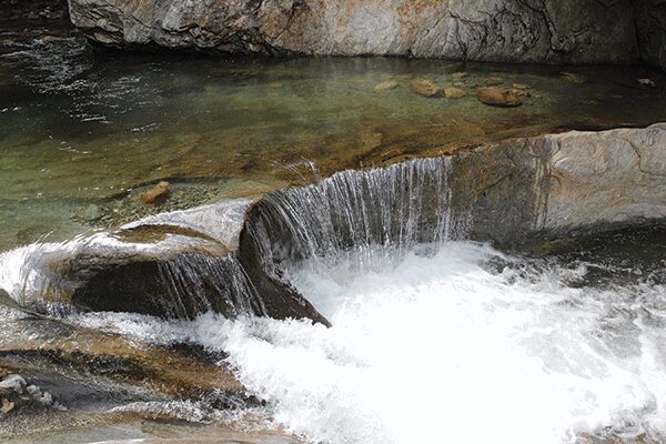
With cliffs and boulders and terraced pools and water-sculpted sluiceways, Warren Falls on the Mad River is an almost cathedral-like work of natural architecture. But on a hot summer day, the falls are transformed into a watery jungle gym, with the under-twenty crowd and accompanying canines well represented. Daredevil divers scramble to narrow ledges 30 feet or more above the river to launch themselves into the deep-green water below. Others throw backflips off of giant riverside boulders, while still others slide down short stretches where the river, over time, has smoothed and shaped the rock into bobsled-like chicanes. Many simply luxuriate in the pools, kept cool in the mountain air, that provide relief from the summer heat.
Cathedral and jungle gym, Warren Falls—in its beauty, its hydraulic energy, its abundant recreational possibilities—is emblematic of a river that is the geographical and spiritual heart of the community that surrounds it. Both now and historically, the river is such an aortal and vital centerpiece that it is, of course, the Valley eponym. Towns have flourished on its banks and hillsides—Warren, Waitsfield, Fayston, Moretown, Middlesex—but they are all bundled into a greater whole, the Mad River Valley. As Kinny Perot, president of Friends of the Mad River, puts it, “Water is the great connector.”
As rivers go, the Mad is barely a flyspeck, flowing northward for just 26 miles from its source in Granville Gulf to its confluence in Middlesex with the Winooski River. And, like all rivers, the Mad is not a singular organism but instead the core constituent of a vascular complex of rivulets that feed tributary streams that in turn feed the river itself. Thirteen noteworthy tributaries flow into the Mad River, as well as innumerable and ephemeral ribbons of water that rise and expire in accordance with rainfall patterns. In all, its watershed is only about 140 square miles—a fraction of the more than 1,000 square miles drained by the Winooski, for example. And compared with the world’s largest watershed, the Amazon River basin, covering more than 2.7 million square miles, the Mad might seem a piddling trickle of utter inconsequence. But, as its name suggests, it is nonetheless a river of robust and sometimes volatile character, upon which the surrounding valley has for centuries depended for agriculture, industry, transportation, recreation, and inspiration.
In fact, it has at times been seen as a river of almost too much character. That’s one reason why the Mad River Valley was a relative latecomer in the overall settlement of Vermont. According to the recent documentary film Hill Farming in the Mad River Valley: Past, Present & Future, early settlers initially resisted building near the river because of its frequent habit of flooding.
Given the surrounding geography of steep hillsides and a narrow valley floor, floods, though usually short-lived, could be sudden and devastating. According to the film, significant flooding has occurred twenty-one times since the late eighteenth century, most notably in 1927, 1998, and 2011, with Tropical Storm Irene. According to Jeff Nelson, a partner in Vanasse Hangen Brustlin (VHB), an environmental consulting firm, the Mad River’s highs and lows “range considerably, from placid to raging, making it a very flashy system from a hydrological standpoint.”
Irene provided a painful demonstration of the river system’s capacity for violent rage. Brooklets no wider than a hand turned quickly into torrents, exploding beyond their banks and overwhelming culverts before converging with compounded force in larger tributaries and, ultimately, the river itself. Roads like Route 100 through Granville Gulf and German Flats Road in Fayston caved in and became impassable rubble. Bridge Street in Waitsfield and the covered bridge for which it is named were so heavily damaged that images were shown on the national news. (Singer Grace Potter, who grew up in the Valley, even wrote a song commemorating the storm, “Nothing but the Water.”)
Homes and businesses near the river’s edge were washed away or rendered uninhabitable, and riverside farmland became inundated with life-choking silt and debris. The river tore away savagely at its banks and reinvented itself, creating new channels to vent its fury.
Irene’s rampage remains fresh in the minds of today’s Valley resident, and while the river’s run of destruction on August 28, 2011, was relatively short-lived—just a few hours, really—its impacts were costly and are still being felt to this day. Financial losses (roughly $200 million for the entire state) stretched well into the millions of dollars—a big hit for a small valley—and the local community was forced to rethink its management plans for stormwater, erosion, and riverside development should future Irene-sized storms strike. Businesses at the river’s edge, like MINT restaurant on Bridge Street, now stock supplies of sandbags as a precaution.
And the river, as a hydrological entity, was forever changed by Irene. Heavy, fast-moving storms two years later caused flooding in Warren Village and Granville Gulf that might not have occurred if feeder streams hadn’t been rerouted and debris deposits hadn’t been left behind by the Irene floods.
But while the river’s occasional incarnation as a destructive force is memorable and startling, for the vast majority of the time the river is a gentle and well-behaved source of life and contentment in the surrounding valley. Thus is the river responsible, to borrow from Dickens, for both the Valley’s best of times and its worst of times, with the former far exceeding the latter in number.
When early settlers finally did accept the river as a life-supporting entity rather than an intemperate rogue, it was not simply as a source of water but as a source of energy. At one time, says Corrie Miller, executive director of Friends of the Mad River, there might have been as many as fifty-nine mills within the watershed—sawmills, gristmills, bobbin mills, and so on—tapping the river system’s hydraulics for energy. Only vestiges of that industrial past remain: a small hydroelectric dam in Moretown, with a 920-kilowatt capacity; and, in Warren, the remains of an old timber crib dam, now in gradual decay, a non-operational historical relic.
There is also a small weir, put in place only during the winter months by Sugarbush, just to the north of the bridge crossing the river between Waitsfield and Warren. First built in 1995, the weir, with an accompanying flume, measures river flow before allowing water to be diverted to fill Sugarbush’s 25-million-gallon snowmaking pond. The pond has become a critical resource for Sugarbush in assuring widespread trail coverage, especially during periods when natural snow might be lean.
The pond is the outcome of a protracted battle two decades ago between the ski area and environmental groups. “‘Water wars’ is how I describe my time there,” says Robert Apple, who now works for Stowe Mountain Resort but who at the time led Sugarbush’s effort to secure water-withdrawal permits. Environmental organizations such as the Conservation Law Foundation argued that withdrawing water for snowmaking would damage fish habitat in the river, and for a decade or more they were able to stymie Sugarbush in Vermont environmental court.
A truce between the ski area and environmentalists was eventually reached, when it was agreed that water could be withdrawn from the river only when the level exceeded the median flow for February, and local, state, and federal permits were granted. February median flow has since become a standard applied to similar water-withdrawal projects around the country, but at the time, according to Nelson of VHB, who consulted for Sugarbush on the issue, it was a novel concept. Sugarbush also agreed to monitor fish populations after the construction of the weir. “The study went on for a period of years,” says Nelson, “and there was no impact.”
The creation of the snowmaking pond represents a turning point, both real and symbolic, in the interface between the river and the people of the Valley—indeed, a change in priorities for the entire state of Vermont. Before the 1990s, dams built within the Mad River watershed had a manufacturing or agricultural raison d’être. The Sugarbush weir, on the other hand, was all about recreation and tourism, which has come to displace agriculture as the state’s leading industry. Tourism contributes between $1.5 billion and $2 billion annually to the state economy, according to various estimates. One study reports that tourism accounts for about 15 percent of Vermont’s economy, a percentage that ranks sixth among U.S. states.
Swimming, kayaking, canoeing, fishing, and skiing (indirectly, through the water supplied by the pond) are now among the principal activities supported by the river, rather than energy production or agriculture. Artists with easels can often be seen along the river’s banks, inspired by the natural beauty of their riparian surroundings.
For stewards of the river, such as Friends of the Mad River, that means a different set of priorities in maintaining the river than might have existed a century—or even just decades—ago.
“While economics are still in play, we see more of the effects of [our] activity on ecology,” says Miller. “What Friends tries to do is balance those values.” A concern for the river’s ecological health is a big shift from the stewardship of days gone by, when not only farms but individual homes would discharge effluents directly into the river. According to Friends of the Mad River, it wasn’t so long ago that outhouses were sometimes built directly over the river, “straight-piping” waste, as Perot puts it. Health experts warned against swimming in the river.
Times, of course, have changed. Friends of the Mad River volunteers regularly monitor E. coli levels, and except on very rare occasions, the numbers come in far below minimum safety standards set by the state. Riparian buffers—mainly trees along the river that also stabilize the river’s banks and provide cooling shade—have been built alongside farmland abutting the river to minimize agricultural runoff.
Swimming holes such as Warren Falls south of Warren Village and Lareau Farm south of Waitsfield Village have now become so popular that parking areas have had to be expanded in the last few years. As part of an annual stocking program, the state released 2,400 rainbow and brook trout into the river this spring, while native fish, mostly absent from the main river, can still be found in tributary brooks. Freeman Brook, which joins the Mad River in Warren, is also known as Kids’ Brook, reserved exclusively for under-fourteen anglers.
According to Matt Crawford, former outdoor editor for the Burlington Free Press and now an outdoors public-relations consultant in the Valley, the Mad isn’t a great river for fishing. “The Winooski, one of the best fishing rivers in the entire state, is a much better fishery,” says Crawford. But he goes on to say that “what makes the Mad great is that it is approachable—not super-technical to wade, not difficult to figure out. There’s nothing better than grabbing lunch and a few beverages at the Warren Store and going higher up [south of Warren].”
When the river runs high in spring, whitewater kayakers have their time of glory, surfing waves produced from melted snow that at one time might have covered Sugarbush trails like Paradise and Stein’s Run. And while Irene was a disaster for many, it was seen as an opportunity for Justin Beckwith, local whitewater enthusiast and director of Nordic programs at Green Mountain Valley School. The Mad in midsummer typically runs at the easygoing pace of about 300 cubic feet per second, as measured at the dam near Moretown. But on the morning of August 29, 2011, after the river had come down from a historic high of 22,900 cubic feet per second, Beckwith jumped into Mill Brook, which parallels Route 17, in his 14-foot boat. He rode the roiling water down the Mad and Winooski Rivers all the way into Lake Champlain, 60 miles in all.
Clearly, however, those were extreme conditions. What Beckwith believes makes the Mad a great river is not its allure for whitewater extremists. Instead, it offers something for paddlers of all abilities using all manner of nonmotorized conveyance: kayaks, canoes, and stand-up paddleboards. In addition to terrific whitewater spots—pockets above Warren Falls, the Punch Bowl between Warren and Waitsfield, the final stretch beyond the Moretown dam—the river also features what Beckwith calls “awesome beginner-level moving water and intermediate rapids.”
As the summer heat recedes and eventually gives way to winter, the paddlers put their boats in storage and swimmers and divers at Warren Falls prepare for the recreational opportunities that winter brings. Under the mantle of winter, the river is a changed environment of ice, quiet, sluggish runnels of chilled water, and mushroom-like tufts of snow on the rocks in the river. It is almost a form of hibernation, as if the river were catching its breath in preparation for all the activity that will resume in the spring. From the exuberance of Warren Falls on a hot summer day to the somber beauty of midwinter, the Mad River has been many things to the many people who have used and abused it over the years, variously a source of pleasure, prosperity, and calamity. For residents and visitors to the Valley, it is life.


